Kalabagh Dam History
Allah has blessed Pakistan with numerous resources, water is one of those gifts. To understand its importance it is necessary to have knowledge of the following:
1. What number of dams and reservoirs are designed on all the rivers and how much work has been done on them?
2. What is the real picture and what are the facts about Kalabagh Dam? Why it is important, necessary, and essential for our country.
3. What are the objections raised by some political parties against Kalabagh Dam, and what is the factual position?
At the time of independence, our newly formed country had no infrastructure for power generation. There were only small diesel or coal-powered generation plants in various cities, but to meet the major requirement we were dependent on India. In 1958 when Field Marshall Ayub Khan took over the government, with all the other important steps, the shortage of power was also taken as a very important issue, and work on a war footing was started.
As already stated we are blessed with many natural resources, especially water. We have five rivers and a number of subsidiaries which can give us sufficient power as well as huge water reservoirs for irrigation if properly planned. Ayub Khan’s Government gave full attention to this side and started an immediate survey for suitable sites for the construction of hydropower projects, water reservoirs/dams, headworks, and barrages as soon as he took over the government in 1958.
Within a short period of six months, a complete study was formed stating the number of places and sites where dams on river Indus and river Jhelum could be constructed as well as sites and places where barrages can be constructed on rivers Chenab, Ravi and Sutlej.
(A) JUDGMENTAL ERROR BY KPK:
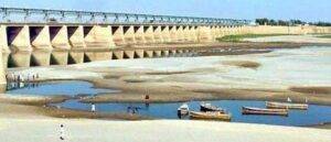
The length of the Kalabagh dam reservoir will be 80 km. From there Nowshera city is 110 km far, and if the dam is full to its ends, the height of Nowshera will be 60 feet above that level. So, the story which has been framed by a political party of KPK, that Nowshera will be submerged in water and that too in the case of destruction of the dam, does not hold any truth and reality in it, rather 800,000 acres of barren land will be irrigated with the rise in the level of the river. This area is 100-150 feet above river level, when the level of the river is raised, it would be easily irrigated.
(B) SUSPICIONS OF SIND:
Around 1,000,000 acres of land in Sind will be irrigated from the water reservoir of Kalabagh-Dam. The politicians and feudal of Sind also have framed a story for their poor and uneducated people that if Kalabagh Dam is constructed, the river Indus will have no water inflow and sea water will enter inside the river bed, damaging the lands. This is just a story to confuse the poor farmers and small landowners so that they don’t get the benefit of water for their fields, which can result in them a better living and educating their children. The feudal have a fear that if these people get an education and better living, the feudal won’t be able to keep them under their thumb, so this sort of story is spread.
Karachi and Sindh are seven meters above sea level, so there is no question of seawater flowing back into the river. Only at the “delta”, the seawater flows in at the time of “Mud-O-Jazz”. Secondly, the bed of the river will not get dry, once the dam is filled, the water flow will be routine and will remain as it is flowing now. Same way, a huge area of Balochistan will also get water for irrigation through this dam’s reservoir.
(C) INDIAN INTRUSION:h
Indian Government is spending a huge amount on the Kalabagh Dam. India doesn’t want that Pakistan ever builds this dam and saves that water which at present is wasted and which would very badly be required in the coming days. Unfortunately, many politicians and feudal are on the Indian pay list just to oppose this dam.
1)- BUNJI HYDROPOWER PROJECT
The proposed Project is located on the Indus River 83 km from Gilgit. It is a planned run of the river hydropower Project. This will generate 7100 Mega Watt, in two stages. The first stage will start the generation of 2800 megawatts and in the second phase total of 7100 megawatts will start generation.
2)- BASHO HYDRO POWER PROJECT
The proposed scheme is along a 1 km lower stretch of Basho Lungma, a left tributary of the Indus River. The confluence of Basho Lungma with the Indus River has located about 40 km downstream northwest of Skardu town and 704 km northeast of Islamabad. This Hydropower Project can generate 40 MW. Its cost is estimated at Rs.91.243 million.
3)- DIAMER BASHA DAM
The proposed project is located on the Indus River, about 315 km upstream of Tarbela Dam, 180 km downstream of the Gilgit-Baltistan capital Gilgit city, and 40 km downstream of Chilas city. The proposed RCC dam would have a maximum height of 272 m, and impound a reservoir of about 8.1 million acre-feet (MAF), with live storage of 6.4 MAF. The mean annual discharge of the Indus River at the site is 1977 cusecs. The dam will impound 15% of the annual river flow. The project would cover an area of 110 square kilometers and the reservoir would extend 100 km upstream of the dam site up to Raikot Bridge on Sharah e Raychem. This hydro project can generate 4500 mega-wall electricity.
4)- DASU HYDROPOWER PROJECT
The proposed Dasu Hydropower Project is a run-of-river project on the Indus River located 7 km upstream of Dasu Town, District Kohistan, Khyber Pakhtunkhwa. The site is 74 km downstream of the proposed Diamer Basha Dam site and 345 km from Islamabad. The project will generate 5400 MW (15 Units @ 360 MW each) of hydroelectric power. It will be completed in two Stages (Stage-I&II). Stage-I will generate 2160 MW (06 Units @ 36 MW each) with annual energy of 12,222 GWh. Stage-I will be completed in five years. The project is being financed by the World Bank.
5)- LOWER SPAT GAH HYDROPOWER PROJECT
The proposed Spat Gah is the left bank tributary of the Indus River in Kohistan District, Khyber Pukhtunkhwa. The confluence of Spat Gah is located 8 km downstream of Dasu town, and 35 km upstream of Patan town. The Project has located 365 km from Islamabad and can generate 496 MW of hydropower.
6)- PATAN HYDROPOWER PROJECT
The proposed Patan Dam site is located on the Indus River about 4 km upstream of the village Patan downstream of Keyal Khwar. The powerhouse is planned on the left bank 4 km downstream of Besham Qila and 305 km from Islamabad. This project will generate 2300 MW of electricity. The cost of this project is estimated at Rs. 731.233 million (2013).
7)- THAKOT HYDROPOWER PROJECT
This proposed hydro project is located in a narrow section of the Indus river, about 3 km downstream of Besham. Distance from Islamabad is about 240 Km. It is designed to generate 4,000 MW of hydropower electricity. Its cost is estimated at Rs. 719.628 Million (2013).